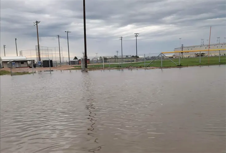
Wildfire smoke results in air quality alerts

PANHANDLE -- The smokey conditions seen in Sidney and much of the Panhandle Thursday have moved to eastern Colorado. 

The National Weather Service Friday and the Colorado Department of Public Health issued an air quality advisory this morning. The CDPH advised the smoke will include an increasing likelihood of respiratory symptoms in sensitive individuals, aggravation of heart or lung disease and premature mortality in people with cardiopulmonary disease and older adults. People with heart or lung disease, older adults, and children should reduce prolonged or heavy exertion.

The smoke is expected to impact much of eastern and Front Range Colorado.

Panhandle resident Thursday experienced a smoky haze settle in prior to afternoon rain showers in the Sidney area. That same storm left flooded streets and fields flooded. Yards and gardens were reported plummeted with hail, high wind and rain. Some hail appeared to be nearly baseball-size in places.

The weekend forecast is for a warming trend. Saturday and Sunday temperatures are expected to be in the mid-70s and dropping to the high 40s overnight.

Sidney's weekend prediction is similar to Sterling with Saturday expected to be in the low 70s and in the 40s overnight. 


NWS Weather Prediction Center College Park MD 358 PM EDT Fri May 19 2023 Valid 00Z Sat May 20 2023 - 00Z Mon May 22 2023 ...Severe thunderstorms and flash flooding possible for the Southern Plains into the Lower Mississippi Valley this evening, shifting eastward on Saturday... ...Well above average, record-breaking warmth continues for interior portions of the Northwest through Saturday, some moderation on Sunday... The upper level pattern will be feature general troughing in the eastern U.S. and ridging for the West heading into the weekend. A progressive upper level disturbance will track from the Great Lakes today into New England this weekend which will be accompanied by a cold front at the surface. Meanwhile, a surface low along the southern Mid-Atlantic coast this afternoon will track northward through Saturday and weaken, bringing a surge of deep moisture northward into southern/eastern New England. These two features will ensure a wet Saturday for many from New York and Pennsylvania into New England. A broad one to two inches of rain is expected from New York City/Long Island into southern and eastern New England along with isolated flash flooding before more pleasant conditions return on Sunday. Farther south along the cold front, from the lower/middle Mississippi Valley into the Ozarks and Texas, severe thunderstorms and flash flooding will be possible through this evening with the threats extending into early Saturday morning. As the cold front moves eastward during the day on Saturday, the threats for severe thunderstorms and flash flooding will shift eastward into the Gulf Coast states and Tennessee Valley but the concerns for adverse weather do not look to be as widespread when compared to today/Friday. Upper level ridging over the western U.S. will continue on Saturday with high temperatures forecast to range 15-25 degrees above average for much of the interior Northwest. Daily record high temperatures will be possible for portions of Washington, Oregon, Idaho, possibly extending into western Montana and northern California. A Pacific trough will move into the Northwest on Sunday which will have the effect of reducing high temperatures a bit for Washington and Oregon but spread the above average warmth into the north-central U.S. Isolated record highs are possible on Sunday for the interior Northwest, but the greatest potential for record breaking heat is expected to be on Saturday. In terms of precipitation, scattered afternoon/evening thunderstorms will occur in areas of terrain with more widespread coverage in the vicinity of the Four Corners region near a weak upper level disturbance. The remainder of the West should remain dry.