
'I zigged when I should've zagged': Large hail smashes pickup windshield near Otis, Colorado
Large hail, damaging winds and a possible isolated tornado triggered severe thunderstorm and tornado warnings in northeast Colorado on Monday night.
 By News Channel Nebraska
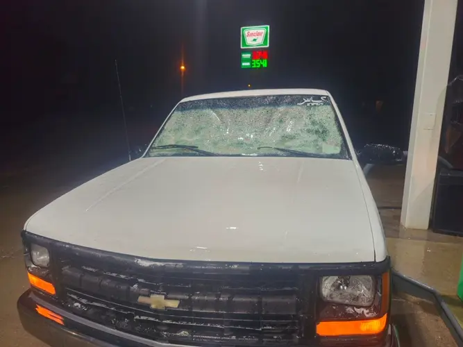
YUMA, Colo. - Large hail, damaging winds and a possible isolated tornado triggered severe thunderstorm and tornado warnings in northeast Colorado on Monday night.
WeatherEye Meteorologist Mike Karow says Yuma, Colo. was dealt the biggest blow with large hail and wind gusts between 60-70 mph.
"The biggest hail reports I saw were around four inches in diameter, so near softball size in the Yuma vicinity," Karow said. "I saw some pictures and video down that way of quite a few windshields taken out by that large hail and even drifts of hail that accumulated when a couple of strong supercell thunderstorms that worked from the southeast of Fort Morgan to near the Akron vicinity. It did produce hail as large as two inches in diameter in the Akron vicinity."
Jd Rogers was four-and-a-half miles south of Otis, Colo. when his white Chevy pickup was struck by the large hail stones. He submitted a photo and video to News Channel Nebraska showing his windshield smashed in by the extreme storms.
The severe weather closed schools Tuesday in Yuma and Wray.
The same line of storms traveled across the Nebraska-Kansas border overnight and spawned tornado warnings Tuesday morning in western Iowa.
Karow says there were reports of a possible tornado southeast Wray.
"Potentially, a tornado sighted in between some lightning flashes down that way, but the National Weather Service will have to get out there today and survey if there was an official touchdown there," Karow said.
According to Karow, non-severe showers and thunderstorms will taper off Tuesday with high temperatures in the upper-50s and lows tumbling to the upper 30s. Temps rebound on Wednesday under dry and sunny conditions in the lower 70s.